

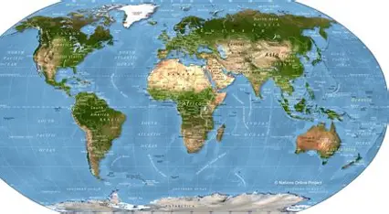

Mountains, Rivers, Deserts, and Landforms – Physical Map of the World
A world physical map depicts the natural features of the surface of the Earth. A physical map, unlike a political map, which focuses mainly on countries and boundaries, helps us learn about mountains, rivers, deserts, oceans, plains, plateaus, and other landforms. In addition, physical maps are important in the study of geography because they reveal how the surface of the Earth differs from one area to another. With the help of a physical world map, we can identify major mountain ranges, large deserts, major rivers, and other natural features of the continents.
What Is a Physical Map of the World?
A physical map of the world is a map that shows the natural features of the surface of the Earth. Generally, it uses different colors or shades to indicate altitude and topography. For example, lowlands can be represented by green colors, whereas mountains are higher and, therefore, can be represented by brown or dark colors. Similarly, oceans, seas, lakes, rivers, and other water bodies are normally depicted in blue.
A physical map does not primarily focus on political boundaries. Instead, it helps us learn about the geographical features of our planet.
Big Mountains on the Physical World Map
Some of the most prominent features of a physical map are mountains. The Himalayas are found in Asia and include Mount Everest, which is the highest mountain above sea level. In addition, several other significant mountain ranges can be found around the world.
Other significant mountain ranges are:
- Andes of South America
- Rocky Mountains in North America
- Alps in Europe
- Atlas Mountains in Africa
- Great Dividing Range in Australia
Moreover, mountain ranges can affect weather, precipitation, rivers, agriculture, transport, and human habitation.
Major Rivers of the World
Another significant feature depicted on a physical world map is rivers. They run through numerous landscapes and, in many cases, supply water for people, agriculture, transportation, and ecosystems.
For example, some of the large rivers are:
- Amazon River in South America
- Nile River in Africa
- Yangtze River in Asia
- Mississippi River in North America
- Ganges River in Asia
- Danube River in Europe
Furthermore, erosion and deposition by rivers can form different landscapes. Over time, rivers can create valleys, floodplains, and deltas.
Large World Map Deserts
Deserts are areas that receive minimal precipitation. Therefore, a physical map can help us determine the location and size of great deserts. The largest hot desert in the world is the Sahara Desert in Africa.
Other large deserts include:
- Arabian Desert
- Gobi Desert
- Kalahari Desert
- Atacama Desert
- Great Victoria Desert
However, deserts can be found in various regions of the world, and they may have quite different topography and climates.
Oceans and Seas
The majority of the world is covered by oceans, and they are a significant feature of any physical world map.
There are five large oceans:
- Pacific Ocean
- Atlantic Ocean
- Indian Ocean
- Southern Ocean
- Arctic Ocean
Among these, the Pacific Ocean is the largest and deepest. In addition, many seas and smaller bodies of water are also shown on physical maps. As a result, these water bodies are important for understanding climate, weather, marine ecosystems, and human activities.
Plains and Plateaus
Mountains and deserts are not the only significant topographical features. Instead, the surface of the Earth is also covered by plains and plateaus. Plains are mostly wide expanses of fairly flat terrain. In many regions, plains are fertile and support large populations and farming practices.
Plateaus are high and comparatively flat terrains. They may occur within mountain regions or extend across large areas. For example, the Tibetan Plateau in Asia and the Deccan Plateau in India are well-known examples.
Large Features on a Physical Map
There are numerous types of landforms that can be represented on a physical map of the world. These include:
- Mountains
- Hills
- Plains
- Plateaus
- Valleys
- Deserts
- Basins
- Canyons
- Coastal areas
- Islands
In general, these features form through natural processes such as erosion, weathering, volcanic activity, and tectonic plate movements.
Use of Colors on Physical Maps
Physical maps are easier to understand because they use different colors. Although mapmakers do not have to follow exactly the same color scheme, most physical maps use a general pattern.
For example:
- Blue: Oceans, seas, lakes, and rivers
- Green: Low-lying land
- Yellow: Drier or higher land
- Brown: Mountains and high places
- White: Very high areas or places permanently covered in snow
However, the precise colors may differ between maps. Therefore, it is important to examine the legend of the map before interpreting its colors.
Physical Map vs Political Map
A physical map and a political map provide different types of geographical information.
| Physical Map | Political Map |
|---|---|
| Shows natural features | Shows political boundaries |
| Displays mountains and landforms | Displays countries and boundaries |
| Shows lakes and rivers | Shows cities and capitals |
| Shows elevation and terrain | Shows administrative divisions |
| Concentrates on physical geography | Concentrates on human geography |
Although the two types of maps provide different information, both are helpful. When we study them together, we gain a broader understanding of the world.
What Is the Importance of a Physical Map of the World?
A physical map of the world helps us understand the natural structure of our planet. For instance, physical maps allow students to find the locations of continents, oceans, mountains, rivers, deserts, and other landforms. Moreover, geographical maps can help researchers examine relationships between the environment, climate, ecosystems, and human activities.
In addition, physical geography can affect the location of cities, crop production, the movement of people, and industries. For example, human settlements have developed around fertile river valleys for thousands of years.
How to Read a Physical World Map
It is simple to read a physical map when you have a basic knowledge of a few elements. First, read the legend to understand the colors and symbols. Then, find the major oceans and continents. Next, locate significant mountains, rivers, deserts, and other landforms. In addition, latitude and longitude lines can help determine the approximate position of geographical features. With regular practice, a physical world map can become an effective tool for studying the geography of the Earth.
Conclusion
Overall, the physical map of the world provides an image of the natural landscape of Earth. It helps us locate great mountains, rivers, deserts, plains, plateaus, oceans, and other physical features. By looking at a physical world map, we can better understand how our Earth is divided between land and water. Furthermore, it helps explain the effects of natural geography on climate, ecosystems, human settlements, agriculture, and transportation. Therefore, for students and anyone interested in geography, learning to read physical maps is an effective way to explore our planet.

Comments are closed.
[…] seven continents of the world are the large landmasses that make up our planet. They contain countries, cities, mountains, deserts, forests, rivers, and many other geographical features. Learning about […]