


Bangladesh Map: Geography, Divisions, Rivers and Location
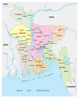
A Bangladesh map can make us comprehend the location, boundaries, rivers, divisions, cities, physical features of the country. Bangladesh is a South Asian nation that is characterize the vast river systems, fertile areas and coastal regions. When one looks at a map, it becomes simpler to see the shape that the country has and how various areas can relate to each other. Bangladesh is a very small country in terms of geographic area, but the country has a mixed geography. Northern plains Maps are useful in giving information about the physical and human geography of the country, even to the coastal areas in the south.
Location of Bangladesh?
Bangladesh is a country in South Asia. It has majority of its land borders with India. On the southeast, Myanmar is situated and to the south is the Bay of Bengal. Bangladesh lies between 20o34 and 26 o 38 north and 88o01 and 92o41 east respectively. Its climate, rivers, agriculture, transportation and settlements have great affect its geographical location.
Bangladesh in the World Map
On a world map, you can find Bangladesh in the northeastern part of South Asia. India borders Bangladesh to the west, north, and most of the east. Myanmar shares a smaller border with Bangladesh in the southeast. The southern part of the country reaches the Bay of Bengal.
Bangladesh lies within one of the world’s largest river delta systems. The Ganges, Brahmaputra, and Meghna river systems have played a major role in shaping the country’s landscape. These rivers carry large amounts of water and sediment, which help form floodplains, wetlands, and the delta.
Bangladesh and its Divisions Map
Bangladesh consists of eight administrative units. These divisions and their large cities are indicated on a political or administrative map. The eight divisions are:
- Dhaka Division
- Chattogram Division
- Raj Shahi Division
- Khulna Division
- Barisal Division
- Sylhet Division
- Rangpur Division
- Mymensingh Division
Different divisions are comprised of a number of districts. Administrative maps allow demonstrating the limits of these areas and simplify the interpretation of the structure of the country.
Major Rivers on Bangladesh Map
One of the most significant features representer a physical map of Bangladesh is rivers. The nation is well endowed with rivers and waterways. Some of the major rivers include:
Padma
Jamuna
Meghna
Teesta
Karnaphuli
Surma
The Padma, Jamuna, and Meghna are especially significant as they constitute a significant river system that shapes the landscape and provides agriculture and transportation. Rivers are also known to form islands, wetlands, floodplains and deltas of rivers.
Physical Features depicted on a Bangladesh Map
A physical map is based on physical features as opposed to administrative areas. A physical map of Bangladesh can indicate:
Rivers and waterways
Floodplains
Hills
Coastal areas
Islands
Wetlands
Forest regions
Low-lying plains
Bangladesh is made up of low fertile plains. The southeastern region however has hilly terrains particularly around the Chattogram Hill Tracts. Another geographical feature of importance is the Sundarbans which are found in the southwestern side of the country. It is among the largest regions of mangrove forests in the world.
Big Cities in Bangladesh Map
A Bangladesh urban map depicts key towns and the position of these towns. The capital and the largest city, Dhaka, is situated in the heart of the country. It is an important political, economic, cultural, and transportation center. Other large cities are:
Chattogram
Khulna
Raj Shahi
Sylhet
Rangpur
Barisal
Mymensingh
Maps can enable us to comprehend how these cities relate to the geographical location of the areas.
What Is So Important about the Map of Bangladesh?
A map is more than a picture of a country. It serves as a valuable geographical tool. A map of Bangladesh helps students and researchers understand:
- The location of Bangladesh
- The countries that border Bangladesh
- The flow of major rivers
- The locations of cities and administrative divisions
- The structure of the country’s landscape
- The locations of coastal and hilly regions
- The distribution of people across different areas
Maps also support many important activities. People use them for transportation, urban planning, disaster management, environmental studies, agriculture, and education.
Various kinds of maps of Bangladesh
Bangladesh has various kinds of maps which depict various features of Bangladesh.
Political Map
A political map indicates a political boundary, divisions, districts, cities and other political features.
Physical Map
A physical map is one that illustrates the natural features like rivers, hills, forests, floodplains and coastlines.
Road Map
A road map is dedicated to highways, roads, bridges, and transportation routes between various locations.
Population Map
A population map depicts the distribution of people in various regions of the country.
Topographic Map
Topographic map gives a lot of information regarding the elevation, landform, waterways, and other physical features. Both varieties of maps offer a variation of how to know Bangladesh.
Conclusion
A map of Bangladesh provides a simple way to learn about the country’s geography. It shows Bangladesh’s location in South Asia and helps us understand its borders, divisions, cities, rivers, and geographical features.
Major rivers and the large delta system shape much of Bangladesh. Therefore, maps help us understand the country’s landscape more clearly.
Whether you are a student, traveler, researcher, or geography enthusiast, studying the map of Bangladesh can help you understand how the country is organized. It also shows how the natural environment has influenced people’s lives and settlements.
The map of Bangladesh reveals the country’s geographical diversity. The northern plains gradually lead to the southern coast, while the Sundarbans covers part of the southwest and hills rise in the southeast.

Comments are closed.
[…] world physical map depicts the natural features of the surface of the Earth. A physical map, unlike a political map, which focuses mainly on countries and boundaries, helps us learn about […]