


Seven Continents of the World: Names, Facts & Geography
The seven continents of the world are the large landmasses that make up our planet. They contain countries, cities, mountains, deserts, forests, rivers, and many other geographical features. Learning about these continents provides a strong foundation for understanding world geography.
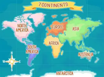
The seven continents are Asia, Africa, North America, South America, Antarctica, Europe, and Australia. Each continent has its own combination of landscapes, climates, wildlife, people, and cultures. Although the continents share the same planet, they differ greatly in size, geography, and population.
Let us explore the seven continents and discover some interesting facts about each one.
What Are the Seven Continents?
The seven continents of the world are:
- Asia
- Africa
- North America
- South America
- Antarctica
- Europe
- Australia
Oceans and seas separate many of these continents. However, some continental boundaries do not follow clear natural features. Instead, geographers and historians have developed different ways to define certain continental boundaries.
1. Asia
Asia is the largest continent in the world by both land area and population. It stretches from the Middle East and Central Asia to East Asia and Southeast Asia.
Countries such as China, India, Japan, Bangladesh, Indonesia, and Saudi Arabia are located in Asia. In addition, the continent contains a remarkable variety of landscapes.
Asia has some of the world’s highest mountains, largest deserts, broad plains, and major rivers. For example, the Himalayas contain Mount Everest, the highest mountain above sea level.
The continent also contains a large share of the world’s population. As a result, Asia includes a wide range of languages, cultures, traditions, and ways of life.
2. Africa
Africa is the second-largest continent by land area. The Atlantic Ocean borders it to the west, while the Indian Ocean lies to the east. In addition, the Mediterranean Sea borders Africa to the north.
Africa contains a remarkable variety of landscapes and wildlife. The Sahara Desert covers a large part of northern Africa and ranks as the world’s largest hot desert.
Besides the Sahara, Africa has tropical rainforests, grasslands, mountains, and extensive river systems. The Nile is one of the world’s best-known rivers and flows through northeastern Africa.
Today, Africa contains more than 50 countries. Therefore, the continent has great cultural and geographical diversity, with many languages, ecosystems, traditions, and wildlife species.
3. North America
North America lies mainly in the Northern and Western Hemispheres. The Arctic Ocean borders it to the north, the Atlantic Ocean lies to the east, and the Pacific Ocean borders it to the west.
Canada, the United States, and Mexico occupy large parts of the continent. Meanwhile, Central America and the Caribbean are also commonly included within the North American continent.
North America contains many important physical features. For example, the Rocky Mountains stretch across western parts of the continent. The Great Plains cover a large area, while deserts, forests, and freshwater lakes add to its geographical variety.
The Great Lakes form one of the world’s largest freshwater systems. As a result, they play an important role in the environment, economy, and transportation of the region.
4. South America
South America lies mainly in the Southern and Western Hemispheres. The Pacific Ocean borders its western side, while the Atlantic Ocean lies to the east.
Brazil is the largest country in South America by both land area and population. Furthermore, the continent contains some of the world’s most important natural environments.
The Amazon Rainforest covers a large part of northern South America. It is the world’s largest tropical rainforest and supports an enormous variety of plants and animals.
In addition, the Andes Mountains run along the western edge of the continent. They form one of the longest mountain ranges on Earth. The Amazon River also crosses a vast area of South America and supports many ecosystems and communities.
5. Antarctica
Antarctica is the southernmost continent on Earth. The continent surrounds the South Pole and remains almost entirely covered by ice.
Antarctica is the coldest continent in the world. Moreover, many areas experience extremely dry and windy conditions. Unlike the other continents, Antarctica has no permanent native human population.
Scientists and researchers from different countries, however, work at research stations across the continent. As a result, small temporary populations live there for scientific research.
Antarctica also plays an important role in Earth’s climate system. Its enormous ice sheets store a large amount of the planet’s freshwater.
6. Europe
Europe is one of the smaller continents by land area. Nevertheless, it has played an important role in world history, science, art, trade, and politics.
Europe lies west of Asia and north of Africa. Countries such as France, Germany, Italy, Spain, Norway, Greece, and the United Kingdom are located there.
The continent contains mountains, plains, rivers, forests, and extensive coastlines. For example, the Alps form one of Europe’s most famous mountain ranges. The Danube and Rhine are also important European rivers.
Europe has a rich cultural and historical diversity. In addition, people across the continent speak many different languages and follow a wide range of traditions.
7. Australia
Australia has the smallest land area of the seven continents. It lies between the Indian and Pacific Oceans.
Australia is unique because the continent is largely occupied by a single country, also called Australia. At the same time, the country and the continent are not exactly the same geographical concept.
The continent has many unique animals, including kangaroos, koalas, and wombats. Furthermore, Australia contains deserts, tropical forests, grasslands, mountains, and long coastlines.
The Great Barrier Reef lies off Australia’s northeastern coast. It forms one of the world’s most famous coral reef systems and supports a wide variety of marine life.
Largest and Smallest Continents
The seven continents differ greatly in size. Asia is the largest continent, while Australia is the smallest by land area.
Antarctica also covers a large area. However, much of its surface remains covered by a thick ice sheet.
A continent’s population does no

Comments are closed.
[…] এই নিয়মিত ওঠানামাকেই বলা হয় জোয়ার-ভাটা। পৃথিবীর প্রায় সব উপকূলীয় অঞ্চলে […]