


How Rivers Shape the Earth: The Power of Flowing Water
How Rivers Shape the Earth is an interesting question in physical geography. Rivers are much more than streams of flowing water. Over thousands and millions of years, moving water can erode rocks, carry sediment, carve valleys, and build new land. From high mountains to coastal plains, rivers constantly change the landscape around them.
How Do Rivers Change the Landscape?
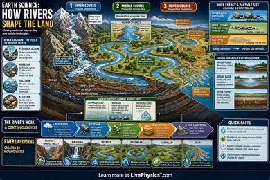
A river changes the land through three main processes: erosion, transportation, and deposition.
Erosion removes soil and rock from the land. Transportation carries these materials downstream. Deposition occurs when a river slows down and drops the sediment it has been carrying.
These processes work together. A river may cut into a mountain in one area while building a fertile plain somewhere else.
River Erosion
Erosion is one of the most important ways rivers reshape the Earth’s surface. Fast-moving water has enough energy to loosen soil and break down rocks.
Rivers can erode their beds and banks in several ways. Moving rocks and sand can scrape against the river channel. Water can also force its way into cracks in rocks and gradually weaken them.
Erosion is usually stronger in the upper course of a river, where the land is often steep and the water flows quickly.
Over time, this process can create deep valleys, narrow gorges, and waterfalls.
How Rivers Form Valleys
In mountainous areas, rivers often flow downhill through steep terrain. The strong downward movement of water can cut deeply into the landscape.
As erosion continues, a V-shaped valley may develop. The river carries broken rock and soil away from the area, making the valley deeper.
Some rivers eventually form spectacular canyons. These landforms show how powerful water can be when it acts continuously over a very long period.
The Grand Canyon in the United States is a famous example of a landscape strongly shaped by river erosion.
River Transportation
Rivers do not only remove material. They also transport it.
A river can carry clay, sand, gravel, and larger pieces of rock. The amount of material a river carries depends on its speed, volume, channel shape, and the size of the sediment.
Fast-flowing rivers have greater energy and can carry larger particles. When the water becomes slower, heavier materials tend to settle first.
This movement of sediment connects different parts of a river system. Material removed from the mountains can eventually reach lowlands, lakes, or the sea.
River Deposition
When a river loses energy, it begins to deposit the sediment it carries. This commonly happens when the river becomes wider, the slope becomes gentler, or the river reaches a lake or ocean.
Deposition can create many important landforms.
One example is a floodplain. Rivers can spread sediment across nearby land during floods. Over time, repeated deposits can create broad and fertile plains.
Another important feature is a delta. A delta forms where a river enters a body of standing water and deposits large amounts of sediment.
How Rivers Create Deltas
Deltas are among the clearest examples of rivers building new land.
As a river approaches the sea, its flow usually becomes slower. The river then loses some of its ability to carry sediment. Sand, mud, and other particles settle near the river mouth.
Over time, these deposits can form new areas of land. Many deltas contain branching channels as the river divides into smaller streams.
Large river deltas support millions of people because their soils can be highly fertile and suitable for agriculture.
Rivers and Floodplains
Floodplains develop along rivers when water regularly spreads beyond the main channel during floods.
Although flooding can cause serious damage, it also brings fresh sediment to the surrounding land. This can improve soil fertility.
Many civilizations developed near major rivers because rivers provided water, fertile land, transportation routes, and food resources.
However, building settlements too close to rivers can increase the risk of flood damage. Modern geography and urban planning therefore consider river behavior when managing communities.
Rivers and Human Geography
Rivers have shaped human societies as well as physical landscapes.
People have traditionally settled near rivers because they provide freshwater for drinking, farming, fishing, and industry. Rivers also offer natural transportation routes.
Major cities have developed along rivers in many parts of the world. Even today, rivers remain important for agriculture, hydroelectric power, transportation, and tourism.
This connection between rivers and human settlement makes river geography an important part of both physical and human geography.
Rivers Can Also Cause Erosion Problems
River erosion is a natural process, but it can sometimes create serious problems for communities.
Strong currents can remove soil from riverbanks and cause riverbank erosion. Homes, farmland, roads, and other structures near unstable banks may become vulnerable.
Human activities can sometimes increase erosion. Removing vegetation, changing river channels, and poorly planned construction can affect the natural movement of water and sediment.
Planting vegetation and using appropriate river-management methods can help reduce erosion in vulnerable areas.
Rivers Never Stop Changing
A river is not a fixed feature of the landscape. Its channel can move, widen, deepen, or divide over time.
Floods can dramatically change river channels in a short period. In contrast, some landscape changes happen so slowly that they are difficult to notice during a person’s lifetime.
Climate, rainfall, geology, vegetation, and human activity can all influence how a river behaves.
This constant change is one reason rivers are so important to geographers and environmental scientists.
Final Thoughts
How Rivers Shape the Earth becomes easier to understand when we look at erosion, transportation, and deposition. Flowing water can carve valleys, move sediment, create floodplains, and build deltas.
Rivers may appear simple when we watch them from a bridge or riverbank, but their long-term influence is enormous. Over geological time, they can transform entire landscapes and create environments where both wildlife and human communities can thrive.

Comments are closed.
[…] to develop. Most mountains form because of movements inside the Earth’s crust, especially the movement and collision of tectonic plates. However, volcanic activity, erosion, and other geological […]