

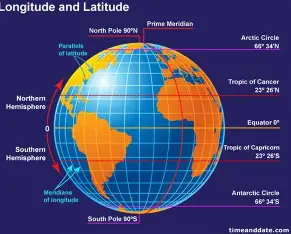

Latitude and Longitude: How do we know where we are on Earth?
The latitude and longitude are two important systems of geographic location that help us locate places anywhere on the earth. These imaginary lines help us to locate an exact position on our planet. Whether you want to locate a city, identify a mountain, find an island or use a GPS device, these imaginary lines help us. But what are latitude and longitude and how do they work together?
What Is Latitude?
Latitude is a measure of how far north or south of the Equator something is. The imaginary Equator is an equidistant circle around the globe that divides the planet into two equal hemispheres, namely the Northern and Southern.
Latitude lines span horizontally in an east-west direction across the globe but measure distance moving pole to pole, or north-south. There is a set of lines which are also known as parallels because they maintain the same parallel position with the Equator.
0° is the latitude of the Equator. From 0° to 90° North, latitude increases as you go toward the North Pole. The Northbound Fig (0° – 90° North) increase toward the South Pole.
For example, a position at 25° North is north of the Equator and a position at 25° South is south.
What Is Longitude?
Longitude tells us how far a location is east or west of the Prime Meridian. Unlike latitude lines, longitude lines run from the North Pole to the South Pole.
The Prime Meridian represents 0° longitude. It passes through Greenwich in London, England. From the Prime Meridian, longitude increases up to 180° east or 180° west.
Longitude lines are also known as meridians. Unlike latitude lines, they are not parallel. All longitude lines meet at the North and South Poles.
Latitude vs. Longitude
Latitude and longitude work together, but they describe different directions.
Latitude tells us whether a location is north or south of the Equator. Longitude tells us whether it is east or west of the Prime Meridian.
Think of a map as a giant grid. Latitude provides the horizontal lines, while longitude provides the vertical lines. Where these lines meet, they create a geographic coordinate that identifies a particular location.
For example, the coordinates of a city might look like 23.8103° N, 90.4125° E. The first number represents latitude, while the second represents longitude.
What Are Geographic Coordinates?
A geographic coordinate is a pair of numbers used to identify a location on Earth’s surface. The first value usually represents latitude, and the second represents longitude.
Coordinates can appear in degrees, minutes, and seconds. They can also appear as decimal degrees, which are commonly used by digital maps and GPS systems.
For example:
23.8103° N, 90.4125° E
This coordinate points to a location in Dhaka, Bangladesh.
Geographic coordinates allow people around the world to describe locations using a common system.
Why Is the Equator Important?
The Equator is one of the most important reference lines in geography. It divides Earth into the Northern and Southern Hemispheres.
It also serves as the starting point for measuring latitude. Locations near the Equator generally experience warmer temperatures because they receive more direct sunlight throughout the year.
Several countries lie along or close to the Equator, including Ecuador, Kenya, Indonesia, Brazil, and Uganda.
The Equator is therefore important not only for navigation but also for understanding Earth’s climate and physical geography.
Why Is the Prime Meridian Important?
The Prime Meridian is the starting point for measuring longitude. It divides Earth into the Eastern and Western Hemispheres.
The line passes through Greenwich, England. The location became an important reference point for global mapping and timekeeping.
Longitude also plays an important role in determining time zones. Since Earth rotates from west to east, different longitudes experience different local times.
This connection between geography and time makes longitude especially useful for navigation and global communication.
How Do Latitude and Longitude Help With GPS?
Modern technology makes extensive use of geographic coordinates. GPS, or Global Positioning System, uses signals from satellites to determine a receiver’s position on Earth.
When you use a navigation app on a smartphone, the system can determine your approximate latitude and longitude. It then uses those coordinates to show your position on a digital map.
This technology helps people find directions, track vehicles, locate places, and navigate across land and sea.
Latitude, Longitude, and Climate
Latitude also has a major influence on climate. As latitude increases away from the Equator, the angle of incoming sunlight generally becomes lower.
This is one reason tropical regions near the Equator tend to have warmer climates, while polar regions experience much colder conditions.
However, latitude is not the only factor that affects climate. Elevation, ocean currents, winds, distance from the sea, and landforms also play important roles.
Understanding latitude therefore helps geographers explain why different parts of Earth have different climates.
How Are Latitude and Longitude Used in Geography?
Geographers use coordinates for many purposes. They can map cities, borders, rivers, mountains, coastlines, and other physical features.
Researchers also use geographic coordinates to study natural disasters, climate patterns, population distribution, and environmental changes.
For example, scientists can record the coordinates of an earthquake’s epicenter. They can then place that information on a map and compare it with other geological features.
Why Are Latitude and Longitude Important?
Latitude and longitude provide a universal way to describe locations on Earth. Without them, identifying an exact position on a large planet would be much more difficult.
They are used in geography, cartography, aviation, shipping, GPS navigation, weather forecasting, scientific research, and many everyday technologies.
From ancient maps to modern satellite navigation, location systems have played an important role in helping humans understand and explore our planet.
Final Thoughts
Latitude and Longitude form a simple but powerful geographic coordinate system. Latitude measures distance north or south of the Equator, while longitude measures distance east or west of the Prime Meridian.
Together, they create a global grid that allows us to identify almost any location on Earth’s surface. Whether you are reading a world map or using GPS on your phone, you are using the basic principles of latitude and longitude to understand where places are located.

Comments are closed.
[…] removes soil and rock from the land. Transportation carries these materials downstream. Deposition occurs when a river slows down and drops the sediment it has been […]